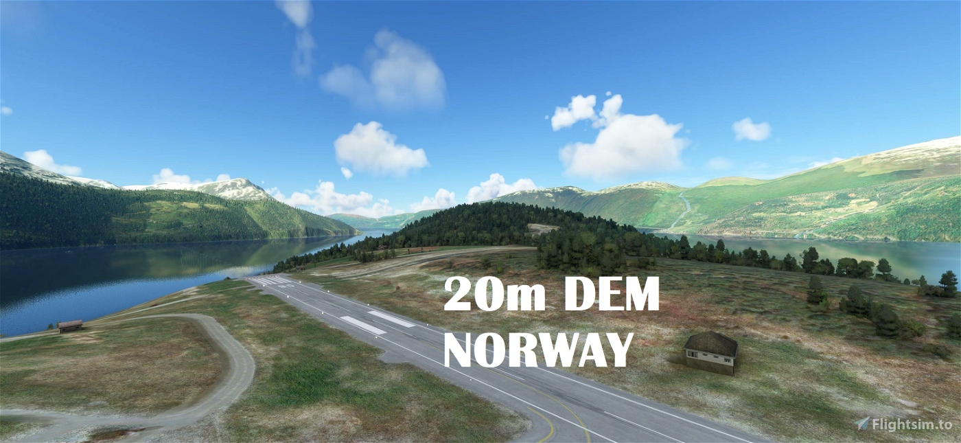


Experience Norway - South! (Part 1)
From Ryvingen to North Cape.
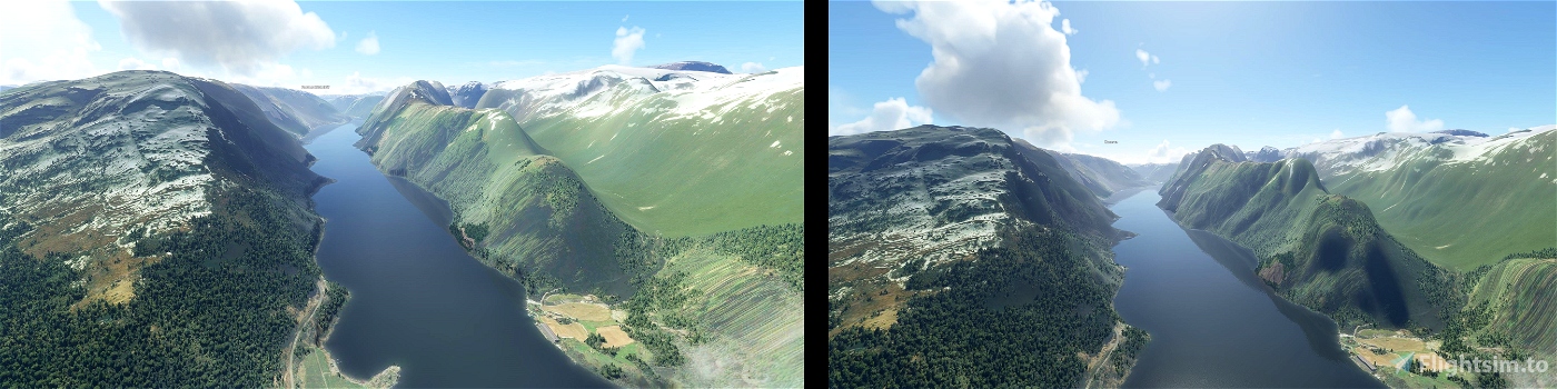
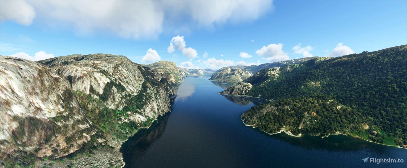
This mod contains customized height profiles for Norway. The mod contains high definition LIDAR DEM data with a mesh resolution of 20m. The height resolution is as good as 0.1m.
The mod does not only provide mountain shapes being very close to reality, but also flattens lakes & rivers and gets rid of any terrain artifacts.
Installation
Download both Files and export it to the community folder. At the end you only have one folder inside the community folder.
IMPORTANT
Disclaimer: The creator of this mod is not responsible for any problems, damage, incompatibilites to other mods or performance issues that might occur.
Please note, that this mod is a very high resolution mesh covering the South of Norway. The elevation data is applied through terraforming rectangles, thus loaded at a certain distance from the player. When travelling fast or at high alitude (wide range of view) there might be too many new rectangles loaded simultaneously and thus stutters might occur.
If you have any stutters you can try and reduce your ingame render settings or uninstall!
If you are mainly flying airliners in high altitude, there is probably no benefit for you in using this mod.
Credits
The elevation data used was a LIDAR 20m height profile compiled by Sonny (https://data.opendataportal.at/dataset/dtm-europe)
It was then transfered into MSFS using MSFS Toolkit by Nool Aerosystems (https://msfs.nool.ee/)
Thank you both and for anyone reading this: Please go ahead and support them!
Thanks Troglodytus for you help!
Enjoy your VFR flights above Norway!

 Mikea.at


As others have mentioned, this mod give a serious stutter issue.
I noticed this during a flight in the northern part of Norway (just above the arctic circle).
Investigating this show that it will flood the RAM of my PC and intermittent use 100% of system RAM. Adding more memory steadied the RAM use to somewhere around 30Gb. The stuttering did not completely dissapear, but as I run a mismatch of RAM stick (8+8+16+16), mys system will only run 32Gb at dual channel, so this might still be the cause as the usage peaks above 32Gb during stutters.
2 years ago
Korsmann
Am experiencing majour game breaking stuttering with this mesh installed. Just had it around ENSE. Seems like it might be an issue with meshes in general and not this one specifically as I had the same with the Crimea free mesh.
2 years ago
Same problem, utilizing every byte of RAM available. Northern DEM most affected, been like this since SU8
2 years ago
CubixRube
ECPatterson
Hi, I did a quick comparison between World Update 5 and this 20m DEM mod. You can see the comparison here https://imgur.com/a/gmJmgdN . It seems WU5 has a much higher resolution with sharper edges and more detail, so I am sticking with WU5.
3 years ago
egs934
Is these files still needed after the Nordic "world update 5" Asobo claims that they now have better mesh/elevation data. I have not jet installed the "5" update since I have no more space on my nvme SSD - have ordered a 2Tb - still waiting. Thanks for your work 😊
3 years ago
actualy i dont know did not make a test so far :)
3 years ago
Mikea.at
jvr009
When you click download there are two files, one called Main and the other mikeaat-dem-norway-File2_YwMeC.7z....what is the second file? How does it relate to the "Main"?
3 years ago
fltsimguy
Hi, anyone tested how this works together with the 1-17-3-0-world-update-v-nordics released today?
3 years ago
DocBamboozle
Hello, I have a problem with the terrain with a payware scenery from orbx - ento torp airport.
Theres a significant incline parallel to the runway and the taxiway signs are floating.
This didn't happen with your package disabled.
3 years ago
orenghe988
This is great.
Working on a project myself, but had to manually correct for elevations.
This saves me a lot of trouble.
3 years ago
mc1102
I have just installed this and noticed it has caused a big trench through the Orbx ENTO scenery and big mounds and hillocks at Aerosoft Trondehim. Is there a way to fix this please?
3 years ago
daanvb
Was flying a320 from Oslo to Tromso, and the frame rate did take a big hit😥 (I know the description says this mod probably brings no benefit at higher altitude but didn't expect the frame rate would drop like this)
Looks like the game was struggling to load the DEM data when I was at a higher altitude, it froze every couple of seconds. Is there a chance the performance could be improved? Thanks🙏
My specs are: Ryzen7 5800X, GTX3080, 32GB RAM @3800MHz, MSFS and all add-ons installed on SSD
3 years ago
strange. i have the same cpu and ram but "only" a 2070super and i did not have any fps issues or stuttering.
3 years ago
jonarni83
SakuraSayaka
Thanks for the Amazing work 😊
3 years ago
charliebravoAT
Thank you so much my dear friend !!! I love Norway!!!
3 years ago
GiuManz
Thank you for these files, they have made an enormous improvement; I have ended up with three Norway DEM zip files which are "mikeaat-dem-norway-north-File1_saMc6", "mikeaat-dem-norway-north-File2_VESoK", and "mikeaat-dem-norway-File1_AcYXD"; are all three needed? Thanks.
3 years ago
It should be 4 files for everything. 2x norway, 2x norway north
3 years ago
Mikea.at
Fab10
Just love this. is it possible for you to do Iceland ?
3 years ago
maybe sometimes :)
3 years ago
Mikea.at
Iair68
Really love heliflying around Aalesund with this DEM. Great job.
But - a major issue..... taxiways are bumpy make the airports useless for other than helis... And terrain close to the airports look terrible.... Tested with ORBX ENAL and Aerosoft ENOV.
3 years ago
there can allways be some problems with addon airports. maybe someone that owns this products can provide a fix. :)
3 years ago
Mikea.at
CaptOle